
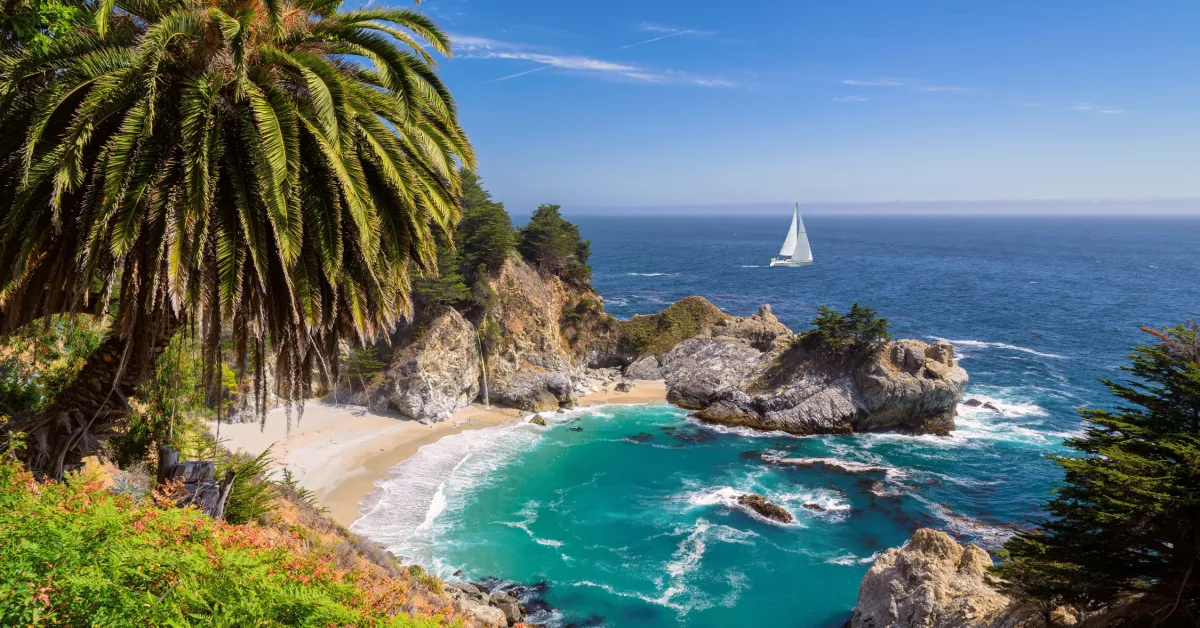
Everyone says they’re going to “drive the PCH.” Most people do a segment of it, declare victory, and post photos at Bixby Bridge. That’s fine. But if you actually commit to this road — all of it, from the sprawling beaches of Southern California up through the cliffs of Big Sur and into the fog-laced redwood coast — you come back changed. This guide is for the full version. Seven to ten days, northbound from Los Angeles to San Francisco, with nowhere to be.
California Highway 1, also called the Pacific Coast Highway, runs just over 656 miles and is the longest state route in California. The full drive from Santa Monica to San Francisco covers roughly 480 miles of Highway 1 proper. Without stops, that’s ten to twelve hours. Spread it over a week and it becomes something else entirely.
Getting There
Fly into LAX. One-way flights from Los Angeles to San Francisco start as low as $28. That makes the northbound structure clean and affordable: fly into LA, drive to San Francisco, fly home. Long Beach Airport (LGB), about 25 miles south of LAX, is worth checking for cheaper fares and far easier ground transport if you’re on a budget carrier.
Pick up your rental car at LAX and start driving. Book through Rentalcars.com to compare rates across Hertz, Alamo, National, and Budget in one search. The one-way drop-off fee from LAX to SFO is the cost most people underestimate. It shifts by date, vehicle class, and inventory. Budget an extra $50–150 for it depending on season. Summer commands the highest premiums. Convertibles are available but book fast in July and August. Reserve one at least three to four weeks out.
Seasonal pricing note: spring (April to early June) and fall (September to October) offer the best combination of lower car rental rates, thinner traffic on the road itself, and better weather for the Big Sur section. Summer works, but expect peak pricing across the board.
The Route
The drive runs northbound from Los Angeles to San Francisco. Start at the Santa Monica Pier, pick up PCH heading north, and don’t stop until the Golden Gate. Going north keeps the ocean on your left for the majority of the drive. That puts the views directly out the driver’s window the whole way. Ending in San Francisco gives you a city worthy of a proper final night.
Key milestones, south to north: Santa Monica and Malibu, Ventura, Santa Barbara, San Luis Obispo, Morro Bay, Cambria, Hearst Castle, Big Sur, Carmel-by-the-Sea, Monterey, Santa Cruz, Half Moon Bay, and San Francisco.
The Big Sur stretch of Highway 1 is the most scenic portion of the entire drive — and it earns that reputation every single mile.
When to Go
Spring (April through early June) and fall (September through October) are the best windows. You get milder weather, thinner crowds, and wildflowers in spring or golden light in fall. Summer is peak season. Expect heavy traffic, packed parking lots, and higher campground and hotel prices. It’s also when the marine layer — that thick morning fog along the coast — is most persistent, especially through Big Sur and the Central Coast.
Fall offers warm days, cooler nights, and less fog. That’s the sweet spot. Book accommodations six to eight weeks out regardless of season.
Road Conditions: What to Know Right Now
As of January 14, 2026, Highway 1 is fully open through Big Sur, allowing continuous travel between Monterey County and San Luis Obispo County for the first time in several years. That’s the good news. As of July 11, 2026, Caltrans is running one-way, signal-controlled traffic at a maintenance zone approximately 5 to 6 miles north of Big Sur village through July 31, and a second one-way control at Rocky Creek Bridge through August 31. Both zones operate 24 hours a day, seven days a week, with delays up to 15 minutes.
Check Caltrans QuickMap the morning you drive Big Sur. Conditions shift fast. Download offline maps before you leave. Cell service is spotty through most of the Big Sur section.
Day-by-Day Stops
Day 1: Los Angeles to Malibu
Start at the Santa Monica Pier. Walk the boardwalk, orient yourself to the ocean, then get on PCH heading north. The real magic starts at Point Dume in Malibu, where a short hike up the bluff gives you one of the best views in all of Southern California.
Stop at El Matador State Beach. It’s one of the best beaches in the entire state and sits completely unmarked from the road. Park at the small dirt pullout off PCH, walk down the narrow path, and you’ll find sea caves, natural arches, and stacked orange rock formations rising from the surf. Free to visit; arrive early on weekends.
Leo Carrillo State Park, near the Ventura County line, is a great stop. Dogs are allowed on the beach on leash, and there are sea caves to explore at low tide. Campsites here run $35–65/night through ReserveCA — one of the most affordable beachfront camping options on the entire drive.
Eat: Neptune’s Net in Malibu serves a seafood sampler and tacos right on PCH, cash-and-card, loud, and wonderful. Expect a line on weekends.

Day 2: Ventura to Santa Barbara
Stop in Ventura for coffee and walk the Main Street pier before continuing north.
Santa Barbara is where the vibe shifts. Everything slows down. The Spanish architecture, the wine tasting rooms on State Street, the mountain backdrop — it’s all absurdly pretty. Stearns Wharf is California’s oldest working pier and the city’s most iconic landmark.
The best dining and nightlife can be found in the Funk Zone, at the end of State Street, right before the ocean. The Funk Zone is a small warehouse district converted to house breweries, wineries, fine dining, and solid social hangouts. Plan a full afternoon here. Dinner at Loquita on State Street runs about $50–60/person for outstanding Spanish coastal cuisine. This is your first justified splurge of the trip.
Sleep: The Californian Hotel Santa Barbara is a solid mid-range choice at $180–220/night.
Day 3: Santa Barbara to San Luis Obispo / Morro Bay
The stretch north of Santa Barbara transitions from Southern to Central California in feel. The road hugs cliffs with the ocean below and golden hills above. Drive it in the late afternoon if you can.
San Luis Obispo (SLO, as the locals call it) is a lively college town with a gorgeous 18th-century mission, a fantastic Thursday night farmers’ market, and a quirky, walkable downtown. Spend an hour in SLO, pick up supplies, and continue to Morro Bay.
Morro Bay is just a short drive from SLO, and Morro Rock is one of the most photographed landmarks on the Central Coast. Pull over. Have a beer at Libertine Pub right on the waterfront. The clam chowder at Giovanni’s Fish Market on the embarcadero is about $12 and worth every cent.
Sleep: The Masterpiece Hotel in Morro Bay runs $150–190/night and puts you walking distance from the water. Or camp at Morro Bay State Park campground for $35/night — the eucalyptus trees and heron rookery make this one of the quieter state park sites on the whole route.
Day 4: Cambria and Hearst Castle
Cambria is a slow town made for slow mornings. Walk Moonstone Beach Drive, which runs parallel to the coast and offers free, uncrowded access to a pebble-strewn beach popular with joggers and seal watchers. The tasting room for Stolo Family Vineyards, about ten minutes inland, pours exceptional Rhône-style reds for $20 a flight.
San Simeon, just up the coast, makes a straightforward overnight base. The elephant seal colony at Piedras Blancas is one of the best wildlife experiences on the entire California coast. The seals haul out from November through March in greatest numbers, but some are present year-round. It’s roadside, free, and genuinely spectacular — especially during pup season in January.
Hearst Castle tours run $30–47/adult depending on the tour type. Book ahead. The Estate Tour is 50 minutes and covers the main house and pools.
Day 5: Big Sur (North Section)
Drive slowly. Pull over at Bixby Bridge and stand on the walkway. The view doesn’t need framing — it fills your entire field of vision.
The McWay Falls Overlook Trail at Julia Pfeiffer Burns State Park is closed for a long-term retaining wall repair project, expected to continue into 2026. The only place to view the falls is from a small viewing area on the side of Highway 1. It’s worth the stop regardless — the 80-foot waterfall dropping onto a sand cove with no footprints is one of the most surreal sights on the coast.
The Hidden Gem: Pfeiffer Beach. Finding it is a little tricky. It sits at the end of Sycamore Canyon Road, between Big Sur Station in the north and the Big Sur Post Office in the south. The road is not signposted. The purple sand here comes from manganese garnet in the cliffs above, and the Keyhole Arch catches the sun at sunset in a way that doesn’t look real. A $15 cash-only vehicle fee is required to enter Sycamore Canyon Road. The road is narrow, winding, single-lane, and cannot accommodate RVs or trailers. Worth every dollar.
Eat: If you only eat at one place in Big Sur, make it Nepenthe. It sits high on the cliffs with unobstructed views over the Pacific. Main courses run $25–38. Reserve a terrace table in advance.
Sleep in Big Sur: Budget options are limited. Fernwood Resort and Big Sur Campground and Cabins offer more affordable alternatives to the high-end resorts. Fernwood Resort cabins start around $175/night. For camping, Pfeiffer Big Sur State Park has tent sites at $35/night — book months ahead in summer.

Day 6: Big Sur (South to Carmel) and Justified Splurge
If you’re going to eat at one fine dining restaurant on this entire drive, it’s Sierra Mar at the Post Ranch Inn. The four-course dinner runs around $175/person. It sits above the clouds on some evenings, on the edge of a cliff, with a view that no photograph captures accurately. The view alone justifies it.
Drive north to Carmel. Carmel Beach is open to dogs off-leash and is one of the more beautiful town beaches in California, framed by Monterey pines and cypress.
Point Lobos State Natural Reserve, just south of Carmel, is the place most visitors to this coast underestimate. The Cypress Grove Trail weaves through old-growth Monterey cypress and ends at headlands where sea otters float on their backs in the kelp below. Entry is $10/vehicle. The park sits approximately 2 miles south of Carmel on Highway 1. Get there early — it fills up by 10am on summer weekends, and rangers turn cars away at the gate.

Sleep in Carmel: The Hofsas House Hotel is a good mid-range option. Ocean-view rooms with a fireplace let you fall asleep to the faint sound of waves on Carmel Beach. Rates from around $180–250/night. Book on Hotels.com.
Day 7: Monterey and 17-Mile Drive
Monterey is 15–20 minutes north of Carmel. The Monterey Bay Aquarium is considered one of the best aquariums in the world, with standout exhibits on jellyfish, sea otters, kelp forests, and deep-sea life. Tickets run $45–60/adult — book ahead online, especially in summer. Located right on Cannery Row, the Spindrift Inn is right on the water with comfortable rooms from $199/night.
The 17-Mile Drive through Pebble Beach is $12/car and can be driven in 30 minutes or lingered over for three hours. The Lone Cypress — a single tree clinging to a granite ledge above the sea — is one of the most photographed trees in America. Go early to have it to yourself.
For a cozy morning bite, head to Katy’s Place in Carmel. Known for its creative takes on eggs Benedict and fluffy pancakes. Breakfast here runs about $18–22 and the line moves fast.
Day 8: Santa Cruz to Half Moon Bay
Santa Cruz is an underrated PCH stop. Walk West Cliff Drive out to Point Santa Cruz for a view over Steamer Lane, one of California’s most famous surf breaks. There’s a surf museum in a building that looks like a lighthouse — worth five minutes.
The Bayside Smoke House in Half Moon Bay serves wood-smoked tri-tip and ribs. Order the combo plate for around $22. Half Moon Bay Brewing Company is right on the harbor and one of the better spots on the coast for a beer with a view.
Not too far from Half Moon Bay is Mavericks, one of Northern California’s most famous big-wave surf breaks. The contest, held when waves hit 25–60 feet, draws the best big-wave surfers in the world. Even off-season, the bluff above Pillar Point is worth the short walk for the view.
Day 9: San Francisco
San Francisco is a fitting finale. Cross the Golden Gate Bridge coming in from the south, then pull into the Marin Headlands overlook on the north side and look back at the city and bay. That view is free.
Don’t leave without Boudin’s clam chowder in a sourdough bread bowl, or Tartine Bakery for pastries that people literally line up for. The Tartine line is real. Go on a weekday morning at 8am and you’ll get in without waiting.
Sleep in San Francisco: The Fairmont San Francisco has survived the city’s most tumultuous history and delivers some of the best views of downtown and the bay. Rates from $250–450/night depending on season. Book on Booking.com. If budget is the priority, the HI San Francisco City Center hostel has dorm beds from $45/night.
What to Skip
Santa Monica Pier. Iconic? Yes. Worth stopping for more than 20 minutes? No. The pier is a tourist machine. Walk to the end, photograph the Ferris wheel, and keep driving. The real Southern California PCH magic doesn’t begin until Point Dume in Malibu.
Solvang. It requires a short detour off Highway 1. It’s cute for about twenty minutes. Unless you’re a committed pastry tourist, don’t lose two hours of daylight on it.
Getting Around
You need a car. There is no version of this trip that works on public transit. Rent a convertible if the budget allows — the marine air and open sky are the entire point. Book through Rentalcars.com and compare rates before committing.
Fill up before entering Big Sur from either direction. Gas in Big Sur runs $1–2 per gallon more than anywhere else on the route, and there are stretches of an hour or more between stations. Gas in Malibu and other coastal towns runs 15–20% higher than inland stations. Fill up in Santa Barbara, Ventura, or Salinas rather than on the coast.
There are no tolls on the Pacific Coast Highway. The only exception is the Golden Gate Bridge in the northbound direction. The toll is $9.75, electronic only, no cash accepted. Register your license plate at BayAreaFastrak.org or pay online within 48 hours of crossing.
PCH Travel Tips
Book all accommodations six to eight weeks out minimum. The entire route is a popular weekend getaway corridor, and Big Sur is the tightest — lodging options are limited and the few that exist fill up fast, especially on summer weekends. Pack layers. Even in July, Big Sur mornings hit 55°F before the marine layer burns off, and the coast runs cold until midday regardless of season. Download offline maps before you leave the city. Google Maps offline works well — download the entire PCH corridor from LA to San Francisco, because cell service drops out for long stretches in Big Sur. Check the Caltrans QuickMap tool before every departure through Big Sur; that is the difference between a smooth drive and a long wait in a turnout. Arrive at Point Lobos before 9am, as the parking lot fills completely by mid-morning on weekends and rangers close the entrance gate when capacity is reached. Pfeiffer Beach is cash only at the gate, so bring $15 in cash before you turn onto Sycamore Canyon Road.
Frequently Asked Questions
How many days do you actually need for the PCH?
At least five days if you want to hit the highlights without feeling rushed. A full week is the sweet spot — it gives you breathing room to linger in Santa Barbara, Big Sur, and Carmel without watching the clock.
Should I drive north or south?
Drive northbound, from Los Angeles to San Francisco. Going north keeps the ocean on your left, which means the views are directly out the driver’s window for most of the route. It also ends in San Francisco, which is a better finale city than Santa Monica. There is no practical reason to drive it southbound.
Is the Big Sur section of Highway 1 open right now?
On January 14, 2026, Caltrans officially reopened the final closed segment of Highway 1, restoring a continuous scenic drive from Carmel in Monterey County all the way to San Simeon and Cambria in San Luis Obispo County. Active one-way traffic controls remain in place through the summer. Check Caltrans QuickMap the day of your drive.
What’s the best single thing to do on the entire drive?
Hike the Cypress Grove Trail at Point Lobos. It’s $10, it takes an hour, and it puts you on a headland above a cove full of sea otters and sea lions. The grove of old-growth Monterey cypress here exists nowhere else in the world. It’s the kind of place that makes you understand why people move to California.
Can I do the PCH in a campervan or RV?
Yes, with one firm exception: Sycamore Canyon Road, leading to Pfeiffer Beach, is a narrow single-lane road that cannot accommodate RVs or trailers. The Big Sur section of PCH has a few tight turnouts that make large rigs stressful, but the route itself is passable. Plan fuel stops carefully — Big Sur has almost no services for long stretches.
Budget Summary
| Category | Budget Option | Mid-Range Option |
|---|---|---|
| Flights to LAX (one-way) | $28–60 | $80–150 |
| Car rental (9 days, one-way LAX to SFO) | $300–450 incl. one-way fee | $500–750 convertible |
| Campsite / hostel per night | $35–45 | — |
| Mid-range hotel per night | — | $150–250 |
| Justified splurge (Sierra Mar dinner) | — | $175/person |
| Hearst Castle tour | $30–47/adult | $30–47/adult |
| Monterey Bay Aquarium | $45–60/adult | $45–60/adult |
| 17-Mile Drive | $12/car | $12/car |
| Point Lobos entry | $10/car | $10/car |
| Daily food (estimate) | $25–40 | $60–100 |
| Gas (full route, estimate) | $80–120 | $80–120 |
| Golden Gate Bridge toll | $9.75 | $9.75 |
Planning your PCH trip and have questions about specific stops, current road conditions, or which sections to prioritize? Write to us at hello@outofmanhattan.com — we read everything.
Related Reading:
The American Southwest on a Budget · Kauai on a Budget · The Kalalau Trail Day Hike · Oahu on a Budget
Leave a Reply